
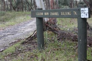
Coliban Main Channel
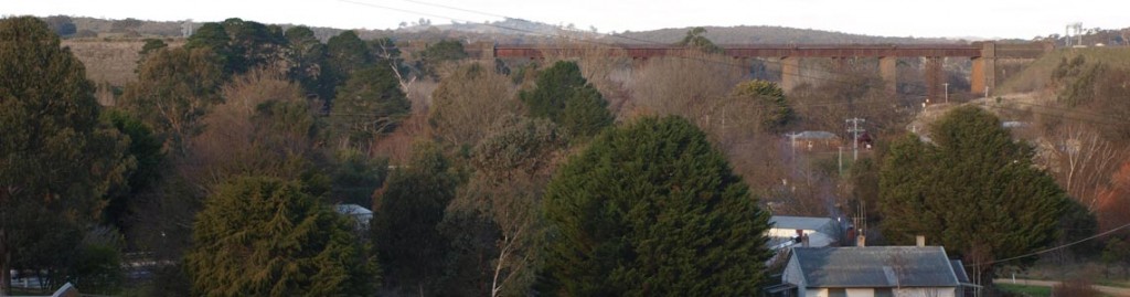
The Coliban Main Channel was constructed in the late 1860s. It is an open gravity channel between Malmsbury and Bendigo and is approximately 70 kilometres long. The channel transfers water from the Malmsbury Reservoir to the Bendigo and Castlemaine Water Treatment Plants, which supply 14 towns in the region, and it also supplies irrigation water to rural water customers of Coliban Water. The channel consists of concrete sections and earthen or rock sections. The concrete sections are around 60 to 80 years old. (taken from Coliban Water website).
The construction of this remarkable feat of engineering is told in a Coliban Water history slide show. The slide show documents the construction of rail and water schemes in central Victoria, driven by the discovery of rich goldfields. The Coliban Main Channel story begins at slide 42 by introducing its designer, Irish civil engineer Joseph Brady.
Today there are walking tracks alongside most of the Channel. North of Mount Alexander the Goldfields Track follows the Channel to Bendigo. In the Taradale district the south end of the walking track begins at the start of the open channel north of the siphon and continues to Elphinstone, north of Taradale, passing under several roads on the way. These roads provide access to the Channel.
Walking and Cycling along the Channel (note: the track is not accessible to horse riders)
The track alongside the Coliban Main Channel can be accessed from any of Tracks 3 to 7. See Taradale district walks map There is easy cycling along the track. Note that some exits/entrances are via stiles. A lone cyclist will need a light bike or strong arms to lift their bike over the fence.
For people with an interest in birds, sections of this track feature in the 2018 publication Castlemaine Bird Walks by Damian Kelly
Tyquins Road (track 3) to Old Drummond Road (track 4) (3 km)
The Channel track begins at the syphon mouth. Follow the track to meet the Old Drummond Road at a stile. Striking views over valley farmland to the north.
Tyquins Road (track 3) to Old Drummond Road (track 4) (3 km)
The Channel track begins at the syphon mouth. Follow the track to meet the Old Drummond Road at a stile. Striking views over valley farmland to the north.
Old Drummond Road (track 4) to Dearden Creek Track (Track 4A) (2 km)
Enter via a gate. This section has a deep incursion into the forest to cross the Kangaroo Creek valley, then open elevated views to the east along the northern section. Gate exit.
Old Drummond Road (track 4) to Dearden Creek Track (Track 4A) (2 km)
Enter via a gate. This section has a deep incursion into the forest to cross the Kangaroo Creek valley, then open elevated views to the east along the northern section. Gate exit.
Dearden Creek Track (Track 4A) to Fryerstown Road (Track 5) (4 km)
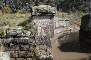
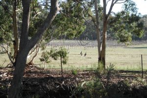
Enter via gate. This is the longest and most diverse section of the channel. Features such as tunnels and overshoots are visible from the track. Sustained views across country, including views of Mount Macedon and the Metcalfe hills on the northern section. Note that the narrow concrete ‘bridges’ that span the channel to carry water across in wet periods are major kangaroo crossing points to and from night grazing areas. There can be heavy traffic at dawn and dusk.
The track meets Fryerstown Road behind Fryerstown Road vineyard.
Gate exit.
Dearden Creek Track (Track 4A) to Fryerstown Road (Track 5) (4 km)
Enter via gate. This is the longest and most diverse section of the channel. Features such as tunnels and overshoots are visible from the track. Sustained views across country, including views of Mount Macedon and the Metcalfe hills on the northern section. Note that the narrow concrete ‘bridges’ that span the channel to carry water across in wet periods are major kangaroo crossing points to and from night grazing areas. There can be heavy traffic at dawn and dusk.
The track meets Fryerstown Road behind Fryerstown Road vineyard.
Gate exit.
Fryerstown Road (Track 5) to Cypress Drive (Track 6) ( 2 km)
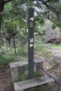
To reach the next section of Channel track, cross the Channel at the end of Fryerstown Road via the bridge into the forest and the start of Old Coach Road. Turn right onto Salt Water Track (note B> <M marker pole)
Go uphill then down a steep hill. Pass the start of No Name Track then look on the right for the track that rejoins the channel via a ‘gap’ stile (easy bike access). Note the large overshoot and tunnel structure that carries creek water over and channel water under. Continue to meet Cypress Drive at a stile.
Fryerstown Road (Track 5) to Cypress Drive (Track 6) ( 2 km)
To reach the next section of Channel track, cross the Channel at the end of Fryerstown Road via the bridge into the forest and the start of Old Coach Road. Turn right onto Salt Water Track (note B> <M marker pole)
Go uphill then down a steep hill. Pass the start of No Name Track then look on the right for the track that rejoins the channel via a ‘gap’ stile (easy bike access). Note the large overshoot and tunnel structure that carries creek water over and channel water under. Continue to meet Cypress Drive at a stile.
Cypress Drive (Track 6) to Wright Street (Track 7) (2 km)
Enter via a stile. After passing through a forested area the track emerges onto the edge of cleared land, with pleasant views of farm land. The last section is noted for its display of wildflowers during spring. Exit via stile. This is the end of the Taradale section.
Note that the Channel track continues on the far side of Wright Street to reach the old Calder highway. After crossing the highway the traveller can pick up the track again on a pleasant diversion around the edge of a section of forest, to reach a gate which exits onto Diggers Way. A few hundred metres along this road is the town centre of Elphinstone and the Elphinstone Pub noted for its hearty meals, including the very popular Sunday roast lunch. An alternative route to Elphinstone is via Wright Street, noted for its beautiful wide road reserve with mature trees.